Sorry to hear you had a bad trip, @RayDunzl . I remember from my rodeo days when it was tough to decide whether to get back in the chute, walk away, or shoot the horse (or bull, especially the bulls...) Hopefully just a (scary) learning experience to be pondered upon before getting back up in the air.

-
WANTED: Happy members who like to discuss audio and other topics related to our interest. Desire to learn and share knowledge of science required. There are many reviews of audio hardware and expert members to help answer your questions. Click here to have your audio equipment measured for free!
You are using an out of date browser. It may not display this or other websites correctly.
You should upgrade or use an alternative browser.
You should upgrade or use an alternative browser.
Soaring
- Thread starter RayDunzl
- Start date
OP
- Thread Starter
- #202
Hopefully just a (scary) learning experience to be pondered upon before getting back up in the air.
No problem getting back up, flew Friday, Saturday, and Sunday, and finally did 5.5 hours in one flight as that is a goal (5hrs) you're expected to accomplish.
So, didn't "go" anywhere, the goal was to just keep it up all day, and fly with whoever came along looking for a thermal to ride.
However, I don't plan on attempting the next goal any time soon, Fly 50km/31 miles from home.
Yesterday was good, over 6,000 feet available during the mid-afternoon. Note all the cloud bases are at the same level. Looking southeast toward Lakeland. Altitude about 5300 feet here.
Around 4pm~5pm, the "Sea Breeze" may come in from the Gulf of Mexico. Recently, it just pushes the clouds east and kills lift with a calm sky behind the front.
Yesterday, however, it got strange like I've not seen (or really noticed) before. Lower dark clouds with convex bases. Cloud bases 1000 feet different heights, soaring beside the lower clouds when coming from under a higher, one, lift along the advancing edge of lower clouds, and you could ride up the side while following the backside...
Here's skirting the east side of a lower one in rising air coming in from the Gulf bumping into and growing a higher one...
At one point I was following some Black Vultures up alongside one, until, unexpectedly, they just turned and flew straight into the could.
I hadn't considered birds flying in cloud before that.
OP
- Thread Starter
- #203
The above pictures were taken with the phone, which was a pain, since I had to unplug it and take it out of the holder etc...
Found my old little Panasonic Lumix from years ago and it still works, so maybe I'll take some more in-flight pics with it if something interesting comes up.
Here's my instrument panel:

Little red thing at the top is the base of the Yaw String on the outside of the canopy, shows the relative angle of the plane to the apparent wind. The plane is more efficient when aligned.
Below it is the all but useless compass that spins around a lot.
Left is Altimeter, guesses altitude via ambient air pressure, with adjustment for barometric pressure changes with weather, reading 3350 feet
Upper left, Air Speed in mph, A little open ended probe in the nose of the plane is pressurized as you ram through the air, reading 52mph or so.
Upper right, electronic Variometer, showing me I'm going up at about 1.7 knots. This device beeps variably as the plane rises, so you don't have to stare at it. The green light indicates you are rising at a rate higher than you were during the last 20 seconds or so (or falling at a lower rate than over the last 20 seconds).
Lower right, another Variometer, this one mechanical, measures amount of air flowing out of (rising) or into (sinking) a flask with a liter or so of capacity. Measures in feet per minute, and reads about 500 fpm up at the moment. It jumps around a lot.
The little rectangular blue thing is an experiment, an aquarium thermometer, with the probe in the air vent, to see what kind of temperature difference there is between rising air (should be a little warmer) and the air around it. Inconclusive yet, though I think I see .4 to .4 degrees F difference. I thought it might be more.

And on the far right, a cell phone using software that calculates all sorts of selectable goodies using GPS. Naviter SeeYou Navigator. There are dedicated devices, but expensive, and this is more than enough for now.

The blue arrow is the current location, the color of the trailing line shows rising (yellow and red) or sinking (green and blue) air. This makes it very easy to home in on rising air. Had I not been taking a picture I probably would have circled back to the red area of the track and the bottom of the screen and played that bump.
There's not much detail on the map because I'm over the swamp east of the airport at the moment.
When you circle, the display zooms in on your circle, indicating which parts of the circle gave more or less lift,
From the Left:
It is calculating no wind at the moment, but previously, it was blowing in the direction of the red arrow on the compass rose.
An hour and a minute since takeoff.
Gained 280 feet the last time I gained some. Just flying around.
Moving 55mph over the ground.
Flown 11.8 miles, using some point-to-point straight line calculation - actually 55 miles or so (an hour at that general speed), but it doesn't count circling in lift.
GPS calculates an altitude of 3425 feet. It rarely agrees with the pressure altitude, there is some conversion possible. Pressure altitude is the standard, it will be wrong (a little), but everyone will likely be equally wrong, so it works.
My "target" is the airport, at a bearing of 82 degrees, only 1.5 miles away, and a glide slope of 3.4 to 1 would put me over the airport at 2102 feet. It would provide more useful information at a greater distance from the airfield. The dashed pink line from the blue position arrow is the direction to the airport (or other target selected).
Currently rising at 150 feet per minute, the three instruments rarely agree on that, since it changes so often,
The previous rise was only 50 feet per minute.
I'm flying in a non-circling path, and since the last circle, the glide ratio was 52 to 1 - drop one foot for 52 feet forward.
Other calculations are available, depending on what you want to see, or for use in navigating through several points on a course.
Here's the airport area looking northwest toward Zephyrhills

"Our" runway is being extended to the lower left for bigger business jet traffic which we hope will not materialize other than for occasional events in town that the Political Person who got the extension authorized and paid for will promote for his well-heeled buddies.
Having bigger business jets and parachutes and gliders mingling isn't the best thing.
Bottom center is SkyDive City, the more experienced jumpers land there, often swooping in for a landing, and they like to "ski" across the pond to a landing. You screw that up you get soaked.
The less experienced jumpers, due to the runway extension taking some of their space, land in the area above and slightly left of the pond, near the wastewater plant and golf course.
Actually, they land all over the place, especially if it is windy and they misjudge.
Our glider club is to the right, around the larger clump of trees near the runway.
Most of the air traffic uses the runway at the top, as that is where the fuel and hangars and whatever else they have is located. Mostly small planes, with a couple of small jets. There's a gyrocopter manufacturer there, so they do test flights of their mewly built machines. There's a banner towing operation on that side, you you see them pick up the banners and head to the beach in the morning, and come back and drop them in the afternoon.
The dense area top right is a trailer park, of which there are many in the area. There's one we call the Trailer Park, but it is out of sight to the upper right.
The white thing at the top left is a water bottling plant. Probably connects to Crystal Springs a couple of miles away and not the sewage plant, but, who knows.
So, 2.6 hours Wednesday, just floating around the airport in a cloudless blue sky.
---
Here's a little time lapse showing thermals making clouds:
Found my old little Panasonic Lumix from years ago and it still works, so maybe I'll take some more in-flight pics with it if something interesting comes up.
Here's my instrument panel:
Little red thing at the top is the base of the Yaw String on the outside of the canopy, shows the relative angle of the plane to the apparent wind. The plane is more efficient when aligned.
Below it is the all but useless compass that spins around a lot.
Left is Altimeter, guesses altitude via ambient air pressure, with adjustment for barometric pressure changes with weather, reading 3350 feet
Upper left, Air Speed in mph, A little open ended probe in the nose of the plane is pressurized as you ram through the air, reading 52mph or so.
Upper right, electronic Variometer, showing me I'm going up at about 1.7 knots. This device beeps variably as the plane rises, so you don't have to stare at it. The green light indicates you are rising at a rate higher than you were during the last 20 seconds or so (or falling at a lower rate than over the last 20 seconds).
Lower right, another Variometer, this one mechanical, measures amount of air flowing out of (rising) or into (sinking) a flask with a liter or so of capacity. Measures in feet per minute, and reads about 500 fpm up at the moment. It jumps around a lot.
The little rectangular blue thing is an experiment, an aquarium thermometer, with the probe in the air vent, to see what kind of temperature difference there is between rising air (should be a little warmer) and the air around it. Inconclusive yet, though I think I see .4 to .4 degrees F difference. I thought it might be more.
And on the far right, a cell phone using software that calculates all sorts of selectable goodies using GPS. Naviter SeeYou Navigator. There are dedicated devices, but expensive, and this is more than enough for now.
The blue arrow is the current location, the color of the trailing line shows rising (yellow and red) or sinking (green and blue) air. This makes it very easy to home in on rising air. Had I not been taking a picture I probably would have circled back to the red area of the track and the bottom of the screen and played that bump.
There's not much detail on the map because I'm over the swamp east of the airport at the moment.
When you circle, the display zooms in on your circle, indicating which parts of the circle gave more or less lift,
From the Left:
It is calculating no wind at the moment, but previously, it was blowing in the direction of the red arrow on the compass rose.
An hour and a minute since takeoff.
Gained 280 feet the last time I gained some. Just flying around.
Moving 55mph over the ground.
Flown 11.8 miles, using some point-to-point straight line calculation - actually 55 miles or so (an hour at that general speed), but it doesn't count circling in lift.
GPS calculates an altitude of 3425 feet. It rarely agrees with the pressure altitude, there is some conversion possible. Pressure altitude is the standard, it will be wrong (a little), but everyone will likely be equally wrong, so it works.
My "target" is the airport, at a bearing of 82 degrees, only 1.5 miles away, and a glide slope of 3.4 to 1 would put me over the airport at 2102 feet. It would provide more useful information at a greater distance from the airfield. The dashed pink line from the blue position arrow is the direction to the airport (or other target selected).
Currently rising at 150 feet per minute, the three instruments rarely agree on that, since it changes so often,
The previous rise was only 50 feet per minute.
I'm flying in a non-circling path, and since the last circle, the glide ratio was 52 to 1 - drop one foot for 52 feet forward.
Other calculations are available, depending on what you want to see, or for use in navigating through several points on a course.
Here's the airport area looking northwest toward Zephyrhills
"Our" runway is being extended to the lower left for bigger business jet traffic which we hope will not materialize other than for occasional events in town that the Political Person who got the extension authorized and paid for will promote for his well-heeled buddies.
Having bigger business jets and parachutes and gliders mingling isn't the best thing.
Bottom center is SkyDive City, the more experienced jumpers land there, often swooping in for a landing, and they like to "ski" across the pond to a landing. You screw that up you get soaked.
The less experienced jumpers, due to the runway extension taking some of their space, land in the area above and slightly left of the pond, near the wastewater plant and golf course.
Actually, they land all over the place, especially if it is windy and they misjudge.
Our glider club is to the right, around the larger clump of trees near the runway.
Most of the air traffic uses the runway at the top, as that is where the fuel and hangars and whatever else they have is located. Mostly small planes, with a couple of small jets. There's a gyrocopter manufacturer there, so they do test flights of their mewly built machines. There's a banner towing operation on that side, you you see them pick up the banners and head to the beach in the morning, and come back and drop them in the afternoon.
The dense area top right is a trailer park, of which there are many in the area. There's one we call the Trailer Park, but it is out of sight to the upper right.
The white thing at the top left is a water bottling plant. Probably connects to Crystal Springs a couple of miles away and not the sewage plant, but, who knows.
So, 2.6 hours Wednesday, just floating around the airport in a cloudless blue sky.
---
Here's a little time lapse showing thermals making clouds:
Last edited:
OP
- Thread Starter
- #204
My nephew has been soaring for the past year or so in southern California. He passed his check ride on Saturday!
View attachment 189766
Congratulations to Carter.
Is he headed towad an ATP, or just want to Fun Fly like old (68 5/6ths) me?
Nice trainer! ASK 21
Curious: I assume the instruments and such are battery-powered, when/how do you charge the battery?
OP
- Thread Starter
- #206
Curious: I assume the instruments and such are battery-powered, when/how do you charge the battery?
Only the electronic variometer is powered.
The others are "mechanical" - air pressure moves the needles. I haven't figured out how such minute pressure changes can spin the altimeter, for instance, but it does.
The battery is a 7 amp hour.. We use these, I think:
It's good for more than one flight.
I added a USB power port for the phone and thermometer, which also has a voltmeter.
Swap it out for another when it gets down towards 12v. There's a little battery box with a velcro strap behind my head in the plane. There are several batteries available for use, most get put back on the charger after one use. A couple of the planes have detachable solar chargers.
Last edited:
OP
- Thread Starter
- #207
For anyone within range and interested:
https://www.soarfl.com/upcoming_events/
2022 Seniors Soaring Championship
Practice Day: Friday, March 11th
Contest Dates: March 12th – March 18th
4024 Soaring Lane
Clermont, FL 34714
+1-352-394-5450

No, I'm not participating other than as a spectator.
https://www.soarfl.com/upcoming_events/
2022 Seniors Soaring Championship
Practice Day: Friday, March 11th
Contest Dates: March 12th – March 18th
4024 Soaring Lane
Clermont, FL 34714
+1-352-394-5450
No, I'm not participating other than as a spectator.
Thanks! I was thinking a small battery and some solar cells would do it.Only the electronic variometer is powered.
The others are "mechanical" - air pressure moves the needles. I haven't figured out how such minute pressure changes can spin the altimeter, for instance, but it does.
The battery is a 7 amp hour.. We use these, I think:
View attachment 190578
It's good for more than one flight.
I added a USB power port for the phone and thermometer, which also has a voltmeter.
Swap it out for another when it gets down towards 12v. There's a little battery box with a velcro strap behind my head in the plane. There are several batteries available for use, most get put back on the charger after one use. A couple of the planes have detachable solar chargers.
View attachment 190579
Altimeters (and barometers, basically the same thing) use a bellows system so small changes get magnified to move the needle. I was thinking of blacksmith or organ bellows like in all the movies (I have been on the bellows for a blacksmith in the primordial past -- they have more modern ways now) but they really look like little stacked discs in the meters, like a cylindrical accordion. They are pre-pressurized and sealed (at sea level or some known altitude) and a gear linkage drives the meter. As you ascend, the air pressure inside the case (through a small hole in my pocket version, though I think airplanes use a pipe to the outside? Note sure...) drops and so the bellows expands since it now has higher pressure than the surrounding air. The higher you go, the less air pressure, and the bigger the bellows grows. The expansion causes the gears to move the meter.
The catch with mine is that it is very sensitive to atmospheric pressure changes, so when a high or low moves through I have to reset the thing. I assume something similar is required to zero the one in an airplane, unless it has some scheme (unknown to me, wrong kind of engineer) to compensate for that. I was thinking once upon a time of a dual system of some sort that would two bellows of different compliance and a differential sensing scheme. Decided electronics was easier. I would guess GPS is used in modern airplanes.
Edit: Found this: https://www.aopa.org/news-and-media...ight-training-magazine/how-it-works-altimeter
OP
- Thread Starter
- #209
Altimeters (and barometers, basically the same thing) use a bellows system so small changes get magnified to move the needle. I was thinking of blacksmith or organ bellows like in all the movies (I have been on the bellows for a blacksmith in the primordial past -- they have more modern ways now) but they really look like little stacked discs in the meters, like a cylindrical accordion. They are pre-pressurized and sealed (at sea level or some known altitude) and a gear linkage drives the meter.
Video shows the surprising mechanism...
Anther video shows how to calibrate - set the local altitude, then disconnect the hands from the barometric pressure, turn the barometric pressure to the current reading, and reconnect the hands.
As you ascend, the air pressure inside the case (through a small hole in my pocket version, though I think airplanes use a pipe to the outside? Note sure...) drops and so the bellows expands since it now has higher pressure than the surrounding air. The higher you go, the less air pressure, and the bigger the bellows grows.
That would be the Static Port (or ports). I have a pair. one on each side of the the rear fuselage, a couple of feet in front of the tail..
I would guess GPS is used in modern airplanes.
GPS is definitely part of modern avionics, but...
"At or above 18,000 feet MSL. All operators will set 29.92 “Hg. (standard setting) in the barometric altimeter"
18,000 is the dividing line putting you into Class A Airspace, where even if there's not a cloud in the sky, you're flying under instrument rules and under direct Air Traffic Control. They tell you how high which way and how fast to go so you don't smack into somebody else at 600mph.
You're above ground obstacles, don't worry about changing barometric pressure, and puts everyone on the same page wherever they are over the US airspace.
Below 18,000, set the Kollsman window to the local barometric pressure, as described elsewhere in the above rule.
Gliders can get a pass above 18,000 feet, in certain areas, if they follow some rules, and announce their intentions, and get permission, in a few "wave" windows out west.
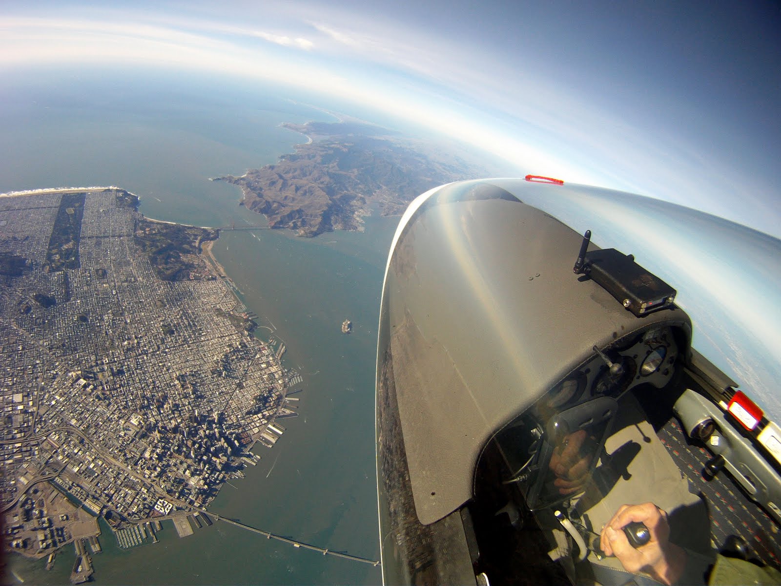
A recent magazine article discussed surprising wave action near the California coast.
Example - https://www.soarcsa.org/index.php?page=wave-operations
Somebody very very high over SanFrancisco:
Last edited:
Cool videos!
I have a vague memory of my (pilot) brother or (ditto) uncle saying something about the variations smoothing out once you got high enough so the main thing was to get a ground check from the airport before landing. My little pocket version has a moveable ring around the case. To calibrate, you look up your altitude, then turn the ring until the hands line up with your current altitude. Never got my Jeep above 18,000'.")
I have a vague memory of my (pilot) brother or (ditto) uncle saying something about the variations smoothing out once you got high enough so the main thing was to get a ground check from the airport before landing. My little pocket version has a moveable ring around the case. To calibrate, you look up your altitude, then turn the ring until the hands line up with your current altitude. Never got my Jeep above 18,000'.
MRC01
Major Contributor
Ray, I really enjoy reading about your soaring experiences. Glad you are having a blast, keep it coming!
The mechanical instruments are pretty neat as they are very accurate and don't require external power. Mainly for historical reasons, as most small airplanes didn't have any electrical systems back in the day (some still don't). The engine doesn't need electrical either since they're magneto fired like lawnmowers (even still today!).
Old fashioned mechanical pressure altimeters are typically accurate to +/- 20 feet from sea level to 18,000'. MUCH more accurate than GPS altitude. For aviation safety / separation, it doesn't matter much if it's right in absolute terms, so long as all the pilots in the area set it to the same sea level pressure so they all read the same. Above 18,000' is class A airspace requires an IFR clearance and most of the airplanes up there move so fast, and are so far above terrain, they all use 29.92" to keep things simple.
The rate of climb indicator has a pressure chamber with a calibrated slow leak hole. When descending, ambient pressure rises before the slow leak can match, so the needle drops. Vice versa for climbing. When you're level the leak catches up and matches ambient pressure so it reads 0.
Airspeed shows the difference in air pressure between the forward facing pitot hole (which goes up as you move faster), and a static pressure port along the side of the airplane (which reads ambient air pressure regardless of your speed). If that static port gets plugged, the airspeed indicator turns into an altitimeter - it shows changes in altitude instead of airspeed.
OP
- Thread Starter
- #212
Monday, a few people flew, as the weather has been a little sketchy recently, windy, cloudy, etc, and Monday (not a normal club day) looked good on the forecast, and somebody organized the day.
Here's a nice thermal.
Cruise along, hit a big bump, pull back on the stick to almost stall (to slow down) and add flaps and start turning in the lift.

13 circles over about 7 minutes and gain 2,550 feet of altitude, 364 feet per minute, 200 feet per circle , to cloud base, and head off toward wherever it looks good a few miles away in the general direction I want to go. Can't go any higher, the cloud will suck you right in, so you get a speed run underneath as you nose down and speed up to keep from being sucked into the cloud.
Red graph is the GPS rise/fall in feet per minute, sampled once a second, it's pretty erratic, no smoothing, depends on the phone GPS vertical accuracy/consistency, so add the blue line for an eyeballed average,
That's how you stay up for a couple of hours. Glide, find lift, repeat. The slant is due to prevailing wind, covering about 3 miles. Looking down vertically the circles don't overlap this day due to wind drift.

That rise is worth around 15 miles of glide, maybe more, maybe less, depending on conditions along the way, if going back down to the starting altitude.
I've got about 70 hours in the plane now, for maybe 3,850 miles of just puttering around, including circling.
Landing is still a challenge, I tend to not get low enough to the runway before it drops in, so need to concentrate on those last moments of flight some more, to eliminate that "bang" down onto the runway. No suspension on the wheel to moderate the touchdown. Maybe the hit is not as hard as it feels, but still...
---
The Seniors Contest hasn't gone well this year, at least two days of it cancelled, due to poor (or expected poor) weather conditions.
---
Found a weather site that indicates this is the windiest time of the year here:

 weatherspark.com

Here's a nice thermal.
Cruise along, hit a big bump, pull back on the stick to almost stall (to slow down) and add flaps and start turning in the lift.
13 circles over about 7 minutes and gain 2,550 feet of altitude, 364 feet per minute, 200 feet per circle , to cloud base, and head off toward wherever it looks good a few miles away in the general direction I want to go. Can't go any higher, the cloud will suck you right in, so you get a speed run underneath as you nose down and speed up to keep from being sucked into the cloud.
Red graph is the GPS rise/fall in feet per minute, sampled once a second, it's pretty erratic, no smoothing, depends on the phone GPS vertical accuracy/consistency, so add the blue line for an eyeballed average,
That's how you stay up for a couple of hours. Glide, find lift, repeat. The slant is due to prevailing wind, covering about 3 miles. Looking down vertically the circles don't overlap this day due to wind drift.
That rise is worth around 15 miles of glide, maybe more, maybe less, depending on conditions along the way, if going back down to the starting altitude.
I've got about 70 hours in the plane now, for maybe 3,850 miles of just puttering around, including circling.
Landing is still a challenge, I tend to not get low enough to the runway before it drops in, so need to concentrate on those last moments of flight some more, to eliminate that "bang" down onto the runway. No suspension on the wheel to moderate the touchdown. Maybe the hit is not as hard as it feels, but still...
---
The Seniors Contest hasn't gone well this year, at least two days of it cancelled, due to poor (or expected poor) weather conditions.
---
Found a weather site that indicates this is the windiest time of the year here:
Zephyrhills Municipal Airport Climate, Weather By Month, Average Temperature (Florida, United States) - Weather Spark
At Zephyrhills Municipal Airport, the summers are long, hot, oppressive, wet, and mostly cloudy and the winters are short, cool, and partly cloudy. Over the course of the year, the temperature typically varies from 46°F to 91°F and is rarely below 32°F or above 95°F.
Can't go any higher, the cloud will suck you right in, so you get a speed run underneath as you nose down and speed up to keep from being sucked into the cloud.
Is there such a thing as IFR glider flying?
I'm not sure how that would work, unless you had a motorglider. Ever considered that route? Is there a nice Stemme in your future, or is the social aspect of the group and the towplane more what it's about?
Why does the cloud suck the glider in?13 circles over about 7 minutes and gain 2,550 feet of altitude, 364 feet per minute, 200 feet per circle , to cloud base, and head off toward wherever it looks good a few miles away in the general direction I want to go. Can't go any higher, the cloud will suck you right in, so you get a speed run underneath as you nose down and speed up to keep from being sucked into the cloud.
OP
- Thread Starter
- #215
Is there such a thing as IFR glider flying?
In the US, I think no.
Maybe in the UK or other countries.
Here, as I may mis-understand it, if you fly IFR you are under the direction of Air Traffic Control. They are more interested in point-to-point flights, separation of aircraft for safety, etc.
Few gliders have the necessary avionics installed for instrument flight, anyway.
There can be exceptions...
Why does the cloud suck the glider in?
As the rising humid air condenses into cloud, it releases heat, and makes that air rise even faster inside the cloud. Air under the cloud is pulled up by the more rapidly rising air within the cloud.

Cloud suck - Wikipedia
Last edited:
Very cool. So using cloud suck a glider pilot could ascend to a very high altitude. Big clouds go very high from what I remember.In the US, I think no.
Maybe in the UK or other countries.
Here, as I may mis-understand it, if you fly IFR you are under the direction of Air Traffic Control. They are more interested in point-to-point flights, separation of aircraft for safety, etc.
Few gliders have the necessary avionics installed for instrument flight, anyway.
There can be exceptions...
As the rising humid air condenses into cloud, it releases heat, and makes that air rise even faster inside the cloud. Air under the cloud is pulled up by the more rapidly rising air within the cloud.
Cloud suck - Wikipedia
en.wikipedia.org
MRC01
Major Contributor
One method when flying powered airplanes is when you are close to the ground about to begin your final flare, shift your eyes to focus on the far end of the runway. It improves one's perception of height so you can touch down smoothly....
Landing is still a challenge, I tend to not get low enough to the runway before it drops in, so need to concentrate on those last moments of flight some more, to eliminate that "bang" down onto the runway. No suspension on the wheel to moderate the touchdown. Maybe the hit is not as hard as it feels, but still...
...
IFR has 2 connotations, related yet different. One is the ability to fly the airplane (keep the shiny side up and navigate) without a horizon or external references. This is possible in any airplane that has the right instruments, like an AI gyro and VOR or GPS. However, if you can't see out the window then you can't maintain separation (avoid other aircraft), which leads to the second connotation: activating an IFR flight plan in the airspace system, so controllers provide aircraft separation for you. To do this, controllers must know for each aircraft, where it's going at what speed and when. When you're IFR, you must plan your flight and fly your plan. With soaring, you might be able to the first in some airplanes, depending on how they are equipped, but the second seems incompatible with the kind of flying you're doing.Is there such a thing as IFR glider flying?
I'm not sure how that would work, unless you had a motorglider. Ever considered that route? Is there a nice Stemme in your future, or is the social aspect of the group and the towplane more what it's about?
OP
- Thread Starter
- #218
One method when flying powered airplanes is when you are close to the ground about to begin your final flare, shift your eyes to focus on the far end of the runway. It improves one's perception of height so you can touch down smoothly.
I know that, but still seem to be a little high, and tend to hold off, trying to get out of the usual landing crab, align the fuselage with the actual direction of motion, before touchdown.
Eye level less that 3 feet above the runway would be about right.
My butt should be about 12" off the pavement at touchdown.
More practice and paying attention needed.
MRC01
Major Contributor
I don't know about gliders, but in many taildraggers, the sight picture when sitting on the runway is the same as what it should be in the flare just before the wheels touch. That's for a 3-point landing. So we familiarize with that while sitting on the runway or taxiing, memorizing clues like how high the horizon is in the windshield, the Lindbergh reference which is looking to the lower left corner of the windshield, which you can see even when the pitch attitude is too high to look directly forward. Then establish that same attitude in the flare and hold it steady until the wheels touch.
Airspeed determines attitude so nailing the exact airspeed is an important part of it. Not +10 / -5 kts like the FAA practical test standards allow, but spot-on exact. Most pilots of powered airplanes tend to land too fast, like they're afraid to slow down to proper landing speed.
After that, it's just as you said: repetition and familiarity, practice until it becomes natural.
OP
- Thread Starter
- #220
I don't know about gliders, but in many taildraggers, the sight picture when sitting on the runway is the same as what it should be in the flare just before the wheels touch. That's for a 3-point landing.
Gliders do a 1-point landing, on the main wheel. The tail wheel doesn't swivel (with exceptions). Keep the tail in the air and use rudder for directional control. Keep flying on the ground, tail up, wings level, until you finally can't. I have to try to keep the nose off the runway (wheel is slightly aft of the center of gravity) at least until getting off into the grass.
There's a steel skid shoe under the nose, works fine on grass, wears quickly on asphalt.
Most gliders rest on main and tailwheel, mine doesn't. I get in the nose goes to the ground and the tail comes up. That's the design.
Some have an additional nosewheel, mostly two-place ships.